


1. The following cases are not system failures
Situations that may influence the determination of the position:
- Sometimes, when driving on a highway/viaduct, the floating point fluctuates.
- When you are driving on a very steep road.
- When driving on a serpentine road, you may find that the floating point fluctuates. This has nothing to do with the radius of the road and the speed of your car. One of the reasons may be that the actual road conditions may differ from the information on the electronic map.
- When turning right/left onto a road that has parallel roads nearby (at a distance of less than 50 m), you may find that the floating point may shift to another road.
- When driving on a wide road with lane changes, you may find that the floating point is wobbling due to the discrepancy with the actual distance.
- Before leaving the underground parking, if you have been driving underground or in a spiral of a multi-level parking for some time, you may find that the floating point is wobbling. When your car is on a rotating lift, the floating point arrow may point in the wrong direction.
- Voice prompt on adjacent road ahead.
- The reported distance may differ from the actual distance.
If any of the following situations occur, the GPS satellite automatically adjusts the location fix as you continue moving.
Problems related to map files:
- When driving from a newly built road to a road recorded in a map file, you may find that the floating point is unstable because the map file cannot display the actual road condition. If you continue driving for a while, the system will automatically adjust the required position using the GPS signal.
- No access due to designated dead end or pedestrian zone
- Opening a new road or closing an old road;
- Direction to a road with a closed passage;
- The route is recalculated without changing the proposed route;
- Direction to normal road instead of viaduct or vice versa;
- If there are several small lanes of traffic near your destination without a normal road, the system will only guide you to a location near your destination.
- Instruction to make a 180 degree turn;
- There is no sign on the adjacent road;
- The turn signal does not correspond to the actual road conditions;
- There is no direction indication or voice prompt for entry/exit when guiding on a highway or expressway.
- The schematic map may not match actual road conditions.
Places where GPS satellite signal reception may be difficult:
- In the tunnels;
- Between tall buildings;
- Under the viaducts;
- In the woods;
When using an external GPS antenna, we recommend placing it on the roof of your car. If your car has an additional roof rack, do not connect the antenna to it.
GPS is under the jurisdiction of the US Department of Defense. The signal accuracy can be forced to be lower, which leads to chaotic movement of the symbol of your car on the map.
Notes on use:
- The floating point may fluctuate before receiving a GPS signal when powering on.
- The floating point may fluctuate when you first use the system after installation.
- The system will automatically adjust its position and direction using GPS signals when the floating point position does not match the actual conditions.
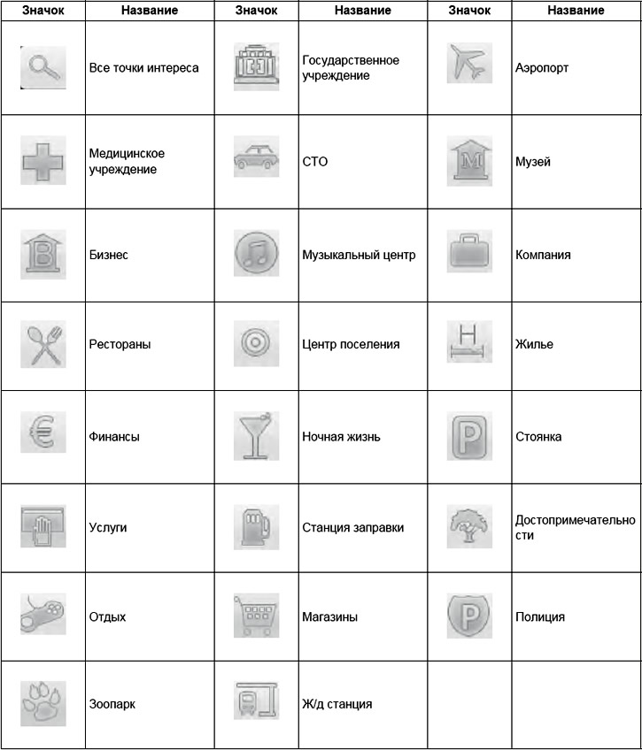
2. Points of Interest Symbols
The original source of the article is the website: «CHEVYMAN»